Pick up pattern from logic fuzzy in mathematics for zonation of landslide hazard
DOI:
https://doi.org/10.14331/ijfps.2017.330101Keywords:
Mathematical, Geology, Fuzzy Logic, Zonation, Landslide, Watershed, Tehran provinceAbstract
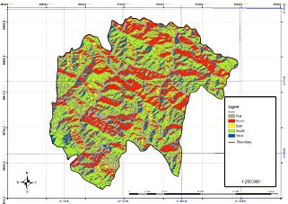
First landslide hazard zonation provided based on Fuzzy logic by landslide area laid on the Slope map, Geology( lithology) map, Aspect map. Then, these maps classes of priority and coming next determine based on existing landslides area in the geology, slope and aspect of maps. In the geology map of tuff, shale, and conglomerate rocks, about with hectare 1440.43 (about percent 23.94) and shelly limestone about with hectare 0.88 (about percent 0.01) and in the slope map, X>45 classes about with hectare 2794 (about percent 46.44 ) and 15-25 classes about with hectare 737 ( about percent 12.25) and in the aspect map, East classes with about hectare 1882 ( about percent 31.28) and west classes with hectare 579 (about percent 9.62) sequential have most and least landslide area. Then, in final drawer to dimension centimeters 2 in region watershed management of map and we counted from 0 until 863 based on geology, slope and aspect that exist only unit 624 counted from 0 until 623. Then (y) units settled sequential, numbers 0 to 105 in very low sensitivity class (one class), numbers 106 to 207 in low sensitivity class (two class), numbers 208 to 345 in average sensitivity class (three class), numbers 346 to 498 in high sensitivity class (four class) and numbers 499 to 623. then landslide hazard zonation provided base on Fuzzy logic.
Downloads
References
Ahmed, B. (2015). "Landslide susceptibility mapping using multi-criteria evaluation techniques in Chittagong Metropolitan Area, Bangladesh." Landslides 12(6): 1077-1095.
Conforti, M., et al. (2014). "Evaluation of prediction capability of the artificial neural networks for mapping landslide susceptibility in the Turbolo River catchment (northern Calabria, Italy)." Catena 113: 236-250.
Ercanoglu, M. and C. Gokceoglu (2002). "Assessment of landslide susceptibility for a landslide-prone area (north of Yenice, NW Turkey) by fuzzy approach." Environmental geology 41(6).
Ercanoglu, M. and C. Gokceoglu (2004). "Use of fuzzy relations to produce landslide susceptibility map of a landslide prone area (West Black Sea Region, Turkey)." Engineering Geology 75(3): 229-250.
Gance, J., et al. (2015). Slope mechanical modelling: contribution of multi-geophysical imagery. Engineering Geology for Society and Territory-Volume 2, Springer: 317-321.
Hong, H., et al. (2016). "Spatial prediction of landslide hazard at the Luxi area (China) using support vector machines." Environmental Earth Sciences 75(1): 40.
Mahmoud, S. H. and A. Alazba (2016). "Integrated remote sensing and GIS‐based approach for deciphering groundwater potential zones in the central region of Saudi Arabia." Environmental Earth Sciences 75(4): 1-28.
Monmonier, M. (1997). Cartographies of danger: Mapping hazards in America, University of Chicago Press.
Pham, B. T., et al. (2016). "Rotation forest fuzzy rule-based classifier ensemble for spatial prediction of landslides using GIS." Natural Hazards 83(1): 97-127.
Pourghasemi, H. R. and N. Kerle (2016). "Random forests and evidential belief function-based landslide susceptibility assessment in Western Mazandaran Province, Iran." Environmental Earth Sciences 75(3): 1-17.
Tien Bui, D., et al. (2012). "Landslide susceptibility assessment in vietnam using support vector machines, decision tree, and Naive Bayes Models." Mathematical Problems in Engineering 2012.
Umar, Z., et al. (2014). "Earthquake induced landslide susceptibility mapping using an integrated ensemble frequency ratio and logistic regression models in West Sumatera Province, Indonesia." Catena 118: 124-135.
Published
Issue
Section
License
Copyright (c) 2017 International Journal of Fundamental Physical Sciences

This work is licensed under a Creative Commons Attribution-NoDerivatives 4.0 International License.


 WorldCat
  Scilit
  ORCID
ORCID  Dimensions
  Mendeley
  Lincoln Library
  Cambridge iDiscover